 Polish Polar DataBase
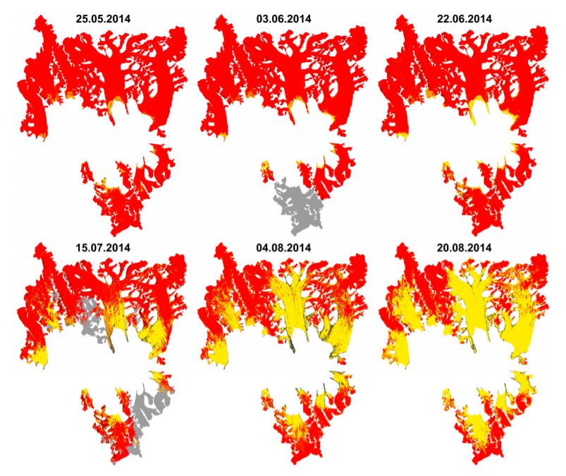
Changes of snow cover extents for glaciers of Hornsund fiord (Spitsbergen, Svalbard) in ablation season 2014
Results of supervised classification of six Landsat 8 images acquired on: 25 May, 3 June, 22 June, 15 July, 4 August and 20 August 2014, covering glaciers in Hornsund fiord. Method of classification: Maximum Likelihood. The results show variability of snow cover areas in melting period of 2014 for glaciers located in Hornsund fiord and larger than 9 km2 (Körberbreen, Samarinbreen, Chomjakovbreen, Mendelejevbreen, Svalisbreen, Hornbreen, Storbreen, Kvalfangarbreen, Mühlbacherbreen, Paierlbreen and Hansbreen).
For more information, please check: https://doi.org/10.3390/w9100804
Overview: Results of Maximum Likelihood classification of Landsat 8 images for analysed glaciers. Red - snow cover, yellow - glacier ice, black - debirs, grey - cloud cover.
- Identification
- Distribution
- Quality
- Spatial rep.
- Ref. system
- Content
- Portrayal
- Metadata
- Md. constraints
- Md. maintenance
- Schema info
Identification
Data identification
Citation
- Date (Publication)
- 2020-12
- Purpose
- scientific and didactic
- Status
- Completed
- Maintenance and update frequency
- As needed
- Theme
-
- snow cover, Landsat, Maximum Likelihood, supervised classification
- Place
-
- Körberbreen, Samarinbreen, Chomjakovbreen, Mendelejevbreen, Svalisbreen, Hornbreen, Storbreen, Kvalfangarbreen, Mühlbacherbreen, Paierlbreen, Hansbreen, Hornsund, Spitsbergen, Svalbard
Legal constraints
- Access constraints
- Intellectual property rights
- Use constraints
- Intellectual property rights
- Spatial representation type
- Grid
- Metadata language
- eng
- Character set
- UTF8
- Topic category
-
- Geoscientific information
- Begin date
- 2014-05-25
- End date
- 2014-08-20
))
Distribution
Digital transfer options
- OnLine resource
-
Overwiew
(
WWW:DOWNLOAD-1.0-http--download
)
Results of Maximum Likelihood classification of Landsat 8 images for analysed glaciers. Red - snow cover, yellow - glacier ice, black - debirs, grey - cloud cover. For more information, please check: https://doi.org/10.3390/w9100804
- OnLine resource
-
Extended human readable information about the dataset
(
WWW:LINK-1.0-http--link
)
Extended human readable information about the dataset
Quality
Data quality
- Hierarchy level
- Dataset
Ref. system
- Reference system identifier
- WGS_1984_UTM_Zone_33N
Metadata
Metadata
- File identifier
- 09d1b7f8-9413-4338-ad12-7a8148cd4157 XML
- Metadata language
- English
- Character set
- UTF8
- Date stamp
- 2020-12-09T11:47:21
- Metadata standard name
- ISO 19115:2003/19139
- Metadata standard version
- 1.0
Overviews
Spatial extent
Provided by
