 Polish Polar DataBase
Subglacial topography of S Spitsbergen glaciers
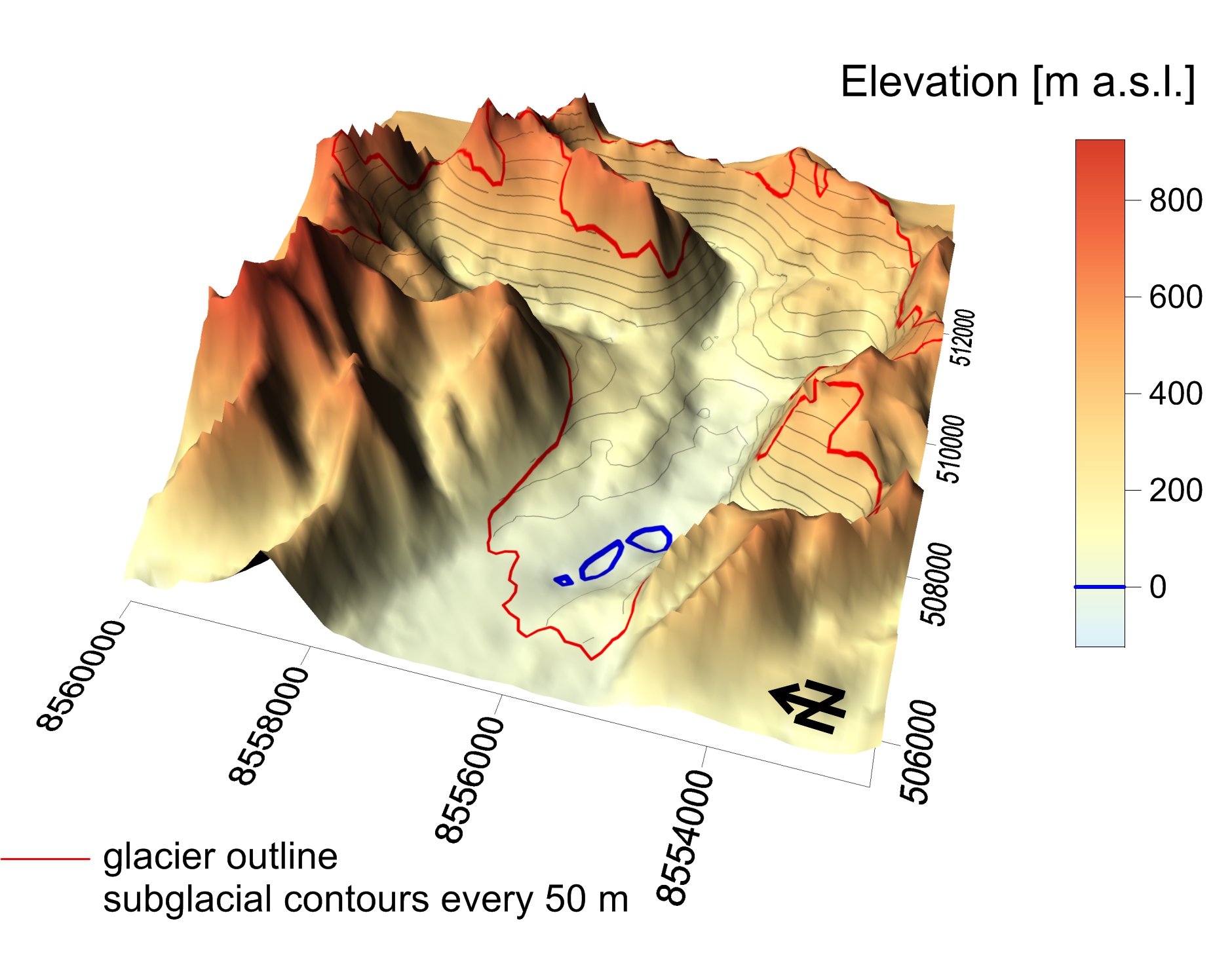
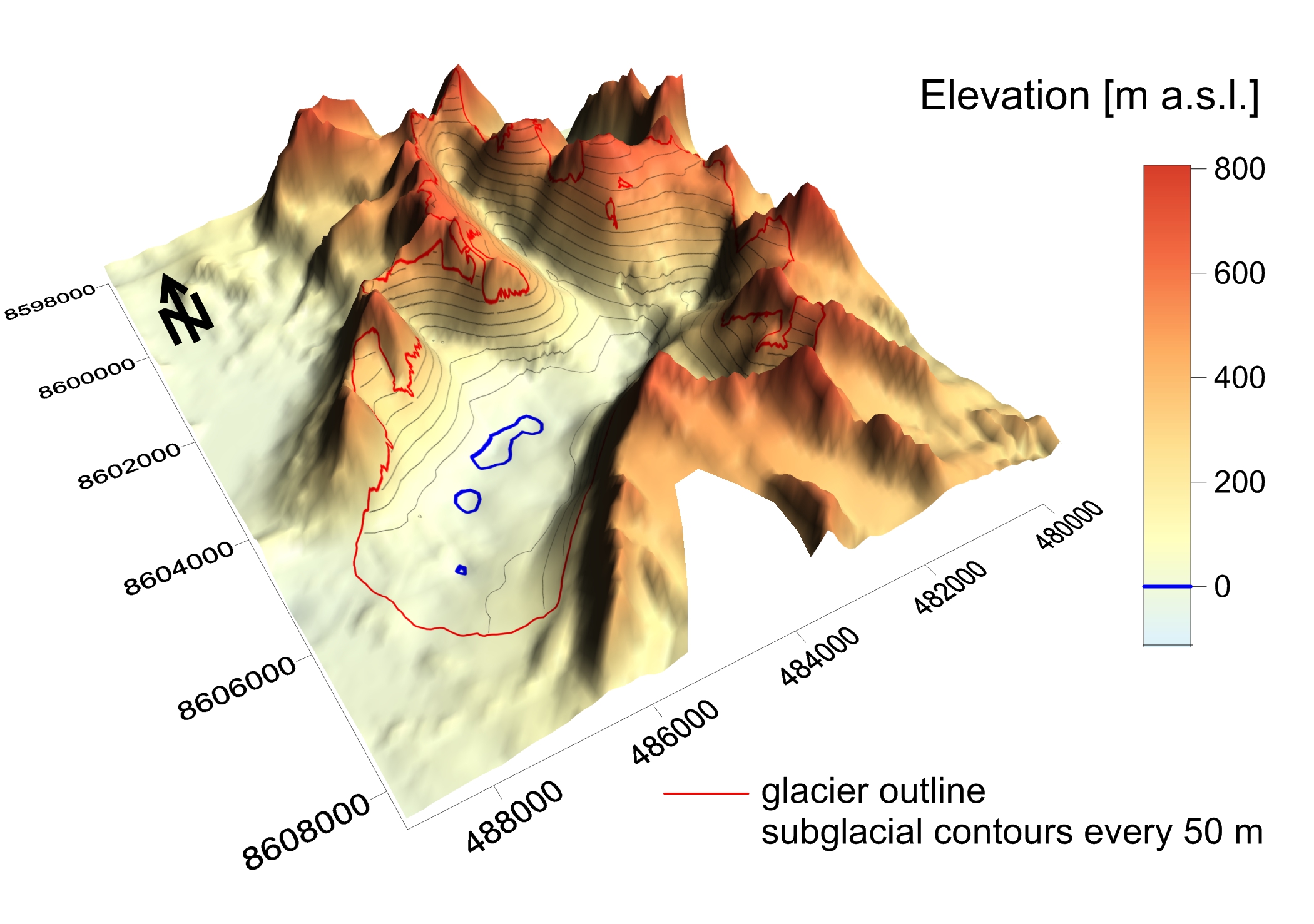
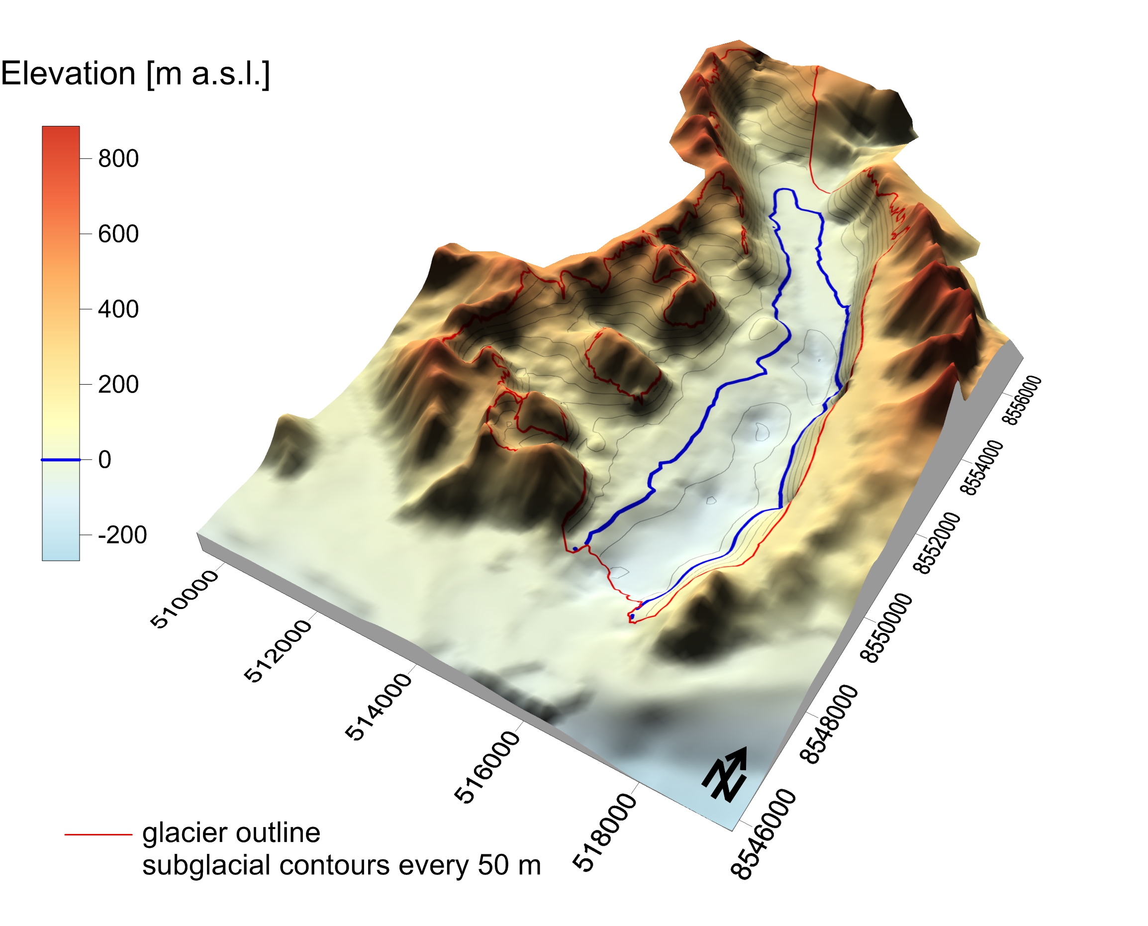
Subglacial topography was derived from radio-echo sounding (RES) survey conducted in spring 2008 by the University of Silesia research team (M. Grabiec and J. Jania) in cooperation with the Institute of Geophysics Polish Academy of Sciences (D. Puczko) and the Maria Curie-Sklodowska University (G.Gajek). The profiles were acquired by the radar system equipped with 25 MHz unshielded antenna pulled behind snowmobile. Traces were recorded every 0.5 s, that translates into 1.5-2.0 trace-to-trace distance depending on the vehicle’s velocity. Traces were positioned by GNSS receiver working in differential mode with 3D accuracy ± 1m. In total over 100 km of RES profiles were acquired on Hansbreen, 66 km on Werenskioldbreen and 43 km on Renardbreen. RES data were processed using standard procedure including: DC-offset, time-zero adjustment, 2-D filter, amplitude correction, bandpass filtering and migration. Time-to-depth conversion applied average radio-wave velocity in glacier ice 16.4 cm ns-1 calculated based on CMP analysis performed on Hansbreen in the same season as the GPR profiling. The ice/bed interface was picked up semi-automatically with RMSE 5.3 ns (0.43 m) (Grabiec, 2017). Then the bedrock elevation data were interpolated over studied glaciers taking into account elevation of nonglaciated surroundings (Grabiec 2017) and bathymetry at the front of tidewater Hansbreen (Grabiec et al. 2012). Finally produced 100 m resolution DEMs are in UTM 33X WGS84 reference system. DEM of 300 m resolution is freely available. For 100 m resolution DEM please contact: mariusz.grabiec@us.edu.pl.
The data were collected and processed under following projects:
• IPY/269/2006 GLACIODYN The dynamic response of Arctic glaciers to global warming
• UE FP7-ENV-2008-1 ice2sea Estimating the future contribution of continental ice to sea-level rise
• PNRF-22-AI-1/07 AWAKE Arctic Climate and Environment of the Nordic Seas and the Svalbard – Greenland Area
• 03/KNOW2/2014 KNOW Leading National Research Centre
Reference:
Grabiec M., Jania J., Puczko D., Kolondra L., and Budzik T., 2012: Surface and bed morphology of Hansbreen, a tidewater glacier in Spitsbergen. Polish Polar Research 38(2): 111-138.
Grabiec M. 2017: Stan i współczesne zmiany systemów lodowcowych południowego Spitsbergenu w świetle badań metodami radarowymi. Wydawnictwo Uniwersytetu Śląskiego, 328 s.
Decaux, L., Grabiec, M., Ignatiuk, D., and Jania, J. 2018: Role of discrete recharge from the supraglacial drainage system for modelling of subglacial conduits pattern of Svalbard polythermal glaciers, The Cryosphere Discuss., https://doi.org/10.5194/tc-2017-219, in review.
- Identification
- Distribution
- Quality
- Spatial rep.
- Ref. system
- Content
- Portrayal
- Metadata
- Md. constraints
- Md. maintenance
- Schema info
Identification
Data identification
Citation
- Date (Publication)
- 2020-12
- Purpose
- scientific and didactic
- Status
- Completed
- Maintenance and update frequency
- Irregular
- Theme
-
- glacier, GPR, bed topography, DEM
- Place
-
- Svalbard, Spitsbergen, High Arctic, Hansbreen, Werenskioldbreen, Renardbreen, Wedel Jarlsberg Land
Legal constraints
- Access constraints
- Copyright
- Use constraints
- Copyright
- Spatial representation type
- Grid
- Metadata language
- English
- Character set
- UTF8
- Topic category
-
- Elevation
- Begin date
- 2008-01-01
- End date
- 2018-12-31
))
Distribution
Digital transfer options
- OnLine resource
-
Ice-free and water-free topography of Hansbreen surroundings - perspective view.
(
WWW:DOWNLOAD-1.0-http--download
)
Topography and bathymetry based on:
Grabiec M., Jania J., Puczko D., Kolondra L., and Budzik T., 2012: Surface and bed morphology of Hansbreen, a tidewater glacier in Spitsbergen. Polish Polar Research 38(2): 111-138.
JANIA J., KOLONDRA L. and SCHROEDER J. (eds) 1992. Hans Glacier. Topographic Map 1:25 000. Uniwersytet Śląski, Université du Quebec, Norsk Polarinstitutt: 1 sheet.
NORSK POLARINSTITUTT. Topografisk kart over Svalbard 1:100000, Blad B12 Torrelbreen.
BARNA Sz. (ed.) 1987. Spitsbergen, 1:25000. Instytut Geofizyki PAN, Służba Topograficzna W.P., Instytut Geodezji i Kartografii, Warszawa, (10 sheets of topographic map).
GIŻEJEWSKI J., MOSKALIK M. and CIEPŁY M. 2010. Bathymetric map and morphology of the bottom of Isbjornhamna (Hornsund, Svalbard). In: XXXIII Sympozjum Polarne. Nauka Polska w Międzynarodowym Roku Polarnym 2007–2009. Abstrakty: 29 (in Polish).
- OnLine resource
-
Hansbreen - subglacial topography
(
WWW:DOWNLOAD-1.0-http--download
)
300 m resolution DEM of Hansbreen subglacial topography within 2004 glacier outline. 100 m resolution DEM available on request. Please contact mariusz.grabiec@us.edu.pl
- OnLine resource
-
Ice-free topography of Werenskioldbreen surroundings - perspective view.
(
WWW:DOWNLOAD-1.0-http--download
)
Topography based on:
Grabiec M. 2017: Stan i współczesne zmiany systemów lodowcowych południowego Spitsbergenu w świetle badań metodami radarowymi. Wydawnictwo Uniwersytetu Śląskiego, 328 s.
NORSK POLARINSTITUTT. Topografisk kart over Svalbard 1:100000, Blad B12 Torrelbreen.
Jania J., Kolondra L., Aas H.F., eds., 2002: Werenskioldbreen and surrounding areas. Spitsbergen, Svalbard, Norway. Orthophotomap, 1 : 25 000. Katowice—Tromsø: Uniwersytet Śląski, Norsk Polarinstitutt.
- OnLine resource
-
Werenskioldbreen - subglacial topography
(
WWW:DOWNLOAD-1.0-http--download
)
300 m resolution DEM of Werenskioldbreen subglacial topography within 2006 glacier outline. 100 m resolution DEM available on request. Please contact mariusz.grabiec@us.edu.pl
- OnLine resource
-
Ice-free topography of Renardbreen surroundings - perspective view.
(
WWW:DOWNLOAD-1.0-http--download
)
Topography based on:
Grabiec M. 2017: Stan i współczesne zmiany systemów lodowcowych południowego Spitsbergenu w świetle badań metodami radarowymi. Wydawnictwo Uniwersytetu Śląskiego, 328 s.
NORSK POLARINSTITUTT. Topografisk kart over Svalbard 1:100000, Blad B11 Van Keulenfjorden.
Zagórski P., 2005: NW part of Wedel Jarlsberg Land (Spitsbergen, Svalbard, Norway). Orthophotomap 1 : 25 000. K. Pękala, H.F. Aas, eds. Lublin.
- OnLine resource
-
Renardbreen - subglacial topography
(
WWW:DOWNLOAD-1.0-http--download
)
300 m resolution DEM of Renardbreen subglacial topography within 2005 glacier outline. 100 m resolution DEM available on request. Please contact mariusz.grabiec@us.edu.pl
- OnLine resource
-
Extended human readable information about the dataset
(
WWW:LINK-1.0-http--link
)
Extended human readable information about the dataset
Quality
Data quality
- Hierarchy level
- Dataset
Ref. system
- Reference system identifier
- WGS84 UTM33X
Metadata
Metadata
- File identifier
- e117fb6e-a425-4ca4-bda4-b872334bc802 XML
- Metadata language
- English
- Character set
- UTF8
- Date stamp
- 2020-12-09T11:47:10
- Metadata standard name
- ISO 19115:2003/19139
- Metadata standard version
- 1.0
Overviews
Spatial extent
Provided by
