 Polish Polar DataBase
Snow cover – Hornsund glaciers
- Identification
- Distribution
- Quality
- Spatial rep.
- Ref. system
- Content
- Portrayal
- Metadata
- Md. constraints
- Md. maintenance
- Schema info
Identification
Data identification
Citation
- Date (Publication)
- 2018-11-27
- Purpose
- scientific and didactic
- Status
- On going
- Maintenance and update frequency
- As needed
- Theme
-
- snow, GPR, Hansbreen
- Place
-
- Spitsbergen, Svalbard, Norway
- Projects
-
- SESS_2019
Legal constraints
- Access constraints
- Intellectual property rights
- Use constraints
- Intellectual property rights
- Spatial representation type
- Text, table
- Metadata language
- English
- Character set
- UTF8
- Topic category
-
- Environment
- Begin date
- 2008-01-01
- End date
- 2017-12-31
))
- Supplemental Information
-
References:
Grabiec M. 2017: Stan i współczesne zmiany systemów lodowcowych południowego Spitsbergenu w świetle badań metodami radarowymi. Wydawnictwo Uniwersytetu Śląskiego, 328 s.
Grabiec M., Puczko D., Budzik T., Gajek G. 2011: Snow distribution patterns on Svalbard glaciers derived from radio-echo soundings. Polish Polar Research, 32(4): 393-421.
Laska M., Grabiec M., Ignatiuk D., Budzik T. 2017: Snow deposition patterns on southern Spitsbergen glaciers, Svalbard, in relation to recent meteorological conditions and local topography. Geografiska Annaler: Series A, Physical Geography 99(3), 262-287.
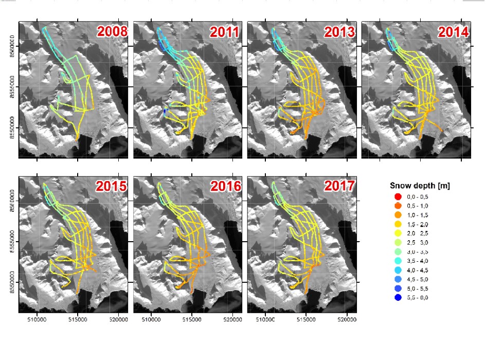
800 MHz shielded antenna used in the GPR survey was fasten to the pulka, whereas control unit and data collection system were placed on the sledge in the front. The measuring set was pulled behind the snowmobile and permanently controlled by the operator. The radar impulse was in constant time interval of 0.2 s (or 0.1 s in some detailed experiments carried out in 2011) what translates on average trace to trace distance c. 1.08 m (s.d. 0.44) (Grabiec 2017). Applied time window was around 80 ns and 1024 samples per trace (other sampling settings possible) (Grabiec 2017). Most coordinates of GPR traces were determined by dual-frequency GPS in postprocessing with average s.d. in XY and Z planes of 0.030 m and 0.100 m respectively (Grabiec 2017). On Tuvbreen and Deileggbreen exceptionally in 2013 when precise positioning was not available due to technical problems, coordinates of navigation class have been used (Grabiec 2017).
Collected GPR data have been processed including coordinates correction, DC removal, time-zero correction, bandpass filtering and signal amplification. Then the time data have been converted into depth scale applying radio-wave velocity (RWV) 0.21 m ns-1 (Grabiec et al. 2011) (see. Fig.2). Time-to-depth conversion was validated by comparing snow depth retrieved from radio echo-sounding data with in-situ snow pits (Laska et al. 2017, Grabiec 2017). As snow records obtained by different methods were usually collected not exactly in the same time and place, depth differences of few centimetres are acceptable.
The ice-snow interface on GPR profile was determined semi-automatically. The function used connects points marked along the same phase of consecutive traces. The accuracy has been estimated as the average standard deviation from five times repeated picking of ice-snow interface along GPR profile from the front to the icedivide on Hansbreen in 2011 (along black dotted line on Fig.2). The average s.d. along the profile was 0.51 ns (0,053 m); in ablation area: 0.43 ns and increased to 0.62 ns in accumulation zone (Grabiec 2017). Larger uncertainty of snow depth determination refers to areas where snow base is ambiguous, eg. crevassed areas filed with snow, superimposed ice and percolation zones and generally accumulation areas. The snow depth accuracy is also affected by the GPR vertical resolution that is 0.066m (assuming ¼ of the wavelength). Description of data collection and processing after Grabiec (2017).
Distribution
Digital transfer options
- OnLine resource
-
Snow distribution on Hansbreen at the end of accumulation seasons 2008 – 2017.jpg
(
WWW:DOWNLOAD-1.0-http--download
)
Snow distribution on Hansbreen at the end of accumulation seasons 2008 – 2017
- OnLine resource
-
Basic characteristics of snow cover (2008-2018).pdf
(
WWW:DOWNLOAD-1.0-http--download
)
Basic characteristics of snow cover (2008-2018)
- OnLine resource
-
Hansbreen_2008.csv
(
WWW:DOWNLOAD-1.0-http--download
)
Hansbreen Snow Depth 2008
- OnLine resource
-
Hansbreen_2011.csv
(
WWW:DOWNLOAD-1.0-http--download
)
Hansbreen Snow Depth 2011
- OnLine resource
-
Hansbreen_2013.csv
(
WWW:DOWNLOAD-1.0-http--download
)
Hansbreen Snow Depth 2013
- OnLine resource
-
Hansbreen_2014.csv
(
WWW:DOWNLOAD-1.0-http--download
)
Hansbreen Snow Depth 2014
- OnLine resource
-
Hansbreen_2015.csv
(
WWW:DOWNLOAD-1.0-http--download
)
Hansbreen Snow Depth 2015
- OnLine resource
-
Hansbreen_2016.csv
(
WWW:DOWNLOAD-1.0-http--download
)
Hansbreen Snow Depth 2016
- OnLine resource
-
Hansbreen_2017.csv
(
WWW:DOWNLOAD-1.0-http--download
)
Hansbreen Snow Depth 2017
- OnLine resource
-
Hansbreen_2018.csv
(
WWW:DOWNLOAD-1.0-http--download
)
Hansbreen Snow Depth 2018
- OnLine resource
-
Extended human readable information about the dataset
(
WWW:LINK-1.0-http--link
)
Extended human readable information about the dataset
Quality
Data quality
- Hierarchy level
- Dataset
Ref. system
- Reference system identifier
- WGS 1984
Metadata
Metadata
- File identifier
- 1be8f239-d91a-4abd-9c3c-e66792bd9c89 XML
- Metadata language
- English
- Character set
- UTF8
- Date stamp
- 2021-02-22T10:51:01
- Metadata standard name
- ISO 19115:2003/19139
- Metadata standard version
- 1.0
Overviews
Spatial extent
Provided by
